NATURAL HERITAGE
"Antigua and Barbuda is a Treasure - Know it as a Pleasure!"
" Come forth into the light of things,
Let Nature be your Teacher".
Falmouth Peak Bird Island Guiana Island Devil's Bridge Wallings Forest Pillars of Hercules Nature Trails Flora & Fauna Bird Watching Frigate Birds Bats Darby's Cave Indian Cave Mangroves Botanical Garden Island Caves
ANTIGUA & BARBUDA - Where Land and Sea Make Beauty ...
 |
 |
|||
|
FALMOUTH HARBOUR |
RENDEZVOUS BAY |
POSITION - Antigua's latitude is 17º 6' north and 61º 45' west and Barbuda is about 28 miles to the north of Antigua at 17º 38' north and 61º 50' west.
AREA - Antigua is 108 sq. miles ( 280 sq. km.) and Barbuda is 62 sq. miles (160 sq. km.) in area.
SIZE - The approximate dimensions of the islands are Antigua: 15 by 12 miles and Barbuda: 14 by 8 miles.
HIGHEST POINTS - Antigua has Boggy Peak, 1,319 ft (402m) and in Barbuda, and the highest point of the the Highlands is 125 ft. (38 m.).
GEOLOGY - Antigua is composed of volcanic and limestone materials of the Oligocene period.
Barbuda is of the Pleistocene period and formed of coral limestones.
 |
||
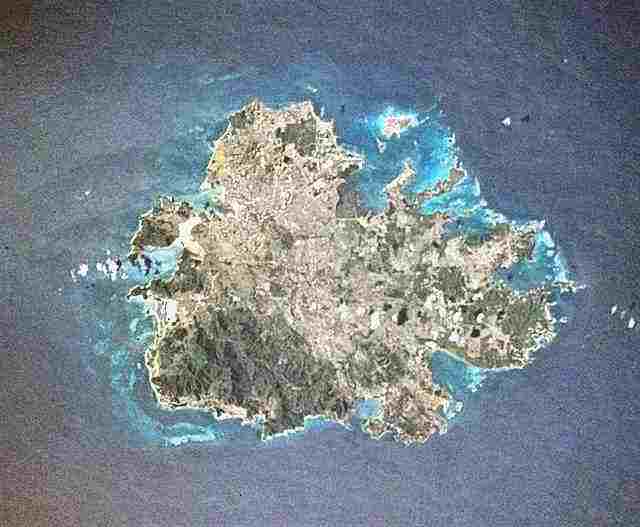
| ANTIGUA FROM SPACE |
FALMOUTH PEAK (or the "Sugar Loaf").
Geologically, Falmouth Peak is the largest intrusive mass in Antigua. Igneous rocks, while liquid, jammed into fractures of weak rock and cooled slowly to form dacite porphyry. The mountain, just over 1,042 ft high, occupies a square mile in area and is just one mile west of Falmouth,
The peak, together with a small area to its west, is covered with mixed evergreen-deciduous forest. It is a small stand of close-canopied forest dominated by silk cotton, red cedar, fig, loblolly, locust and Spanish oak. No alien species occur among the dominants. The physiognomy of this forest fragment is highly suggestive of rain forest, with abundant lianes and epiphytes, large buttresses on the silk cotton and locust trees, and many ferns on the forest floor. The absence of aliens and the inaccessible location of this stand suggests it may be one of the few relics of an evergreen, hydrophytic forest that formerly covered the higher slopes and summits of Antigua.
The local name for this peak is the ‘Sugar Loaf”. Brown crystallized sugar was once poured into long pointed ceramic vessels called sugar pots, so the brown molasses in the crystals would drain off. When the sugar was taken out days later it had formed into a pointed ‘sugar loaf’, hence the name of this peak.
No trail exists up the mountain. A nature trail from Falmouth would pass through several vegetation types of the park and would probably be very popular with hikers. (See photos near top)
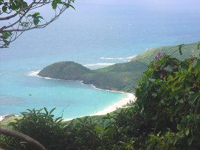
BIRD ISLAND
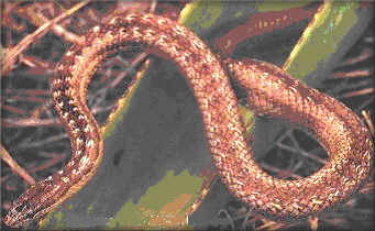
This important environmental area includes six small offshore islands in North Sound on the north-east side of Antigua. Great Bird Island is a tiny islet lying almost three kilometres north-east of Antigua. Measuring just 20 acres, it is the only place on Earth where you can see an Antiguan Racer in the wild. The entire world population of this snake lives on the island.
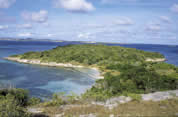
Great Bird Island was named by sailors who were amazed at the number of birds that they found living and nesting there, it is a miniature paradise. As well as being the last refuge of the Antiguan racer, it is also home to a variety of other endangered creatures including a rare lizard, brown pelicans, West Indian whistling ducks and red-billed tropicbirds. Luckily for the snake, there are no mongooses on the island, but, until recently, hundreds of black rats lived there. The rats were eliminated by the Antigua Racer Conservation Project.
A long, narrow coral ridge with 30 metre-high cliffs runs along the east side of the island. The ridge drops down to a flat sandy area, covered with grass and a few scattered plants and trees. The white sand beaches at either end of the sandbar are the main attraction for visitors. Further west, where the land rises again, the island is covered with forest that is almost too thick to walk through.
Over 20,000 tourists visit Great Bird Island every year. Unfortunately, not everyone treats this wonderful island with the respect it deserves. Some visitors drop litter, start fires, disturb nesting birds and even kill the harmless Antiguan racer, so there is a great need of legislation.
THE FIVE SURROUNDING ISLANDS are Red Head Is, Rabbit Is, Lobster Is, Exchange Is and Hell’s Gate.
A CHRONOLOGICAL HISTORY
500 BC Archaic Amerindians lived in the area collecting seafood.
600 AD Arawakan speaking Indians relied on the area for their subsistence. A few of their artifacts have been found on Great Bird Island.
1735 Bird Is. was an isolation area for Joint Evil & Black Leprosy for enslaved Africans.
1915 Bertie Jarvis sold Bird Island for £16.
1982 A small Humpback whale was stranded on Little Bird Island Reef.
A White Sperm whale was also washed up at Little Bird Island.
1990 Tourists went to Bird Island at an average of 17,264 persons per year.
1995 There were about 50 of the rare Racer Snake (Alsophis antiguae) on Bird Is.
1995 The Antigua Racer Snake Conservation Project was initialized.
2001 Over 20,000 visitors a year picnic at Bird Island.
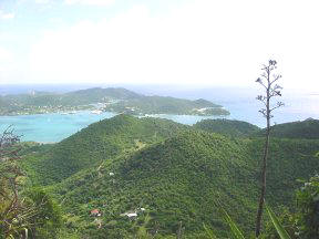
GUIANA ISLAND - An Ecological Gem
Guiana Island, is the largest of the North Shore Islands of Antigua. It is still undeveloped and is home to many species of wildlife. Other smaller islands are scattered in the calm clear waters of the area, with picturesque names such as Maiden Island, Great Bird Island, Galley, Redhead, Rabbit, Lobster, Exchange, London Bridge and Hell's Gate Islands.
Guiana Island is only about three hundred feet from the main island of Antigua, so it is possible to attach cables which enable a barge to be pulled back and forth for access. It is a low island, with its highest point approximately fifty feet. It is almost two and a half miles long and about half a mile across. It was named by English settlers from Guiana (now known as Guyana) in about 1667. They emigrated to it when their country was surrendered to the Dutch by the Treaty of Breda in 1667.
Three groups of people have inhabited Guiana Island in the past. The first were Archaic, the second were of Arawakan speaking Amerindians and the third were Europeans and Africans of the historic age. The island was owned by Charles Tudway of Parham Hill estate in the mid 18th century and was leased to Edward Evanson, who owned two houses on Guiana Island. Hon. Edward Byam, Council Member, occupied one of the houses in 1749. Evanson died in 1760 in debt of £11,000, due to an extended drought. A new lease was made to his heir. In 1812, Sir William Codrington III bought Guiana Island for £4,272 and it remained within the Codrington family until 1929. Up to recently, the old Great House was in fairly good structural condition, but now it is uninhabited.
In 1991, the Guiana Island Society was planned, with the aim to create a wildlife sanctuary on the island. It was proposed that the Great House be restored to provide facilities for a reception area, a lodge, an office and an interpretation centre. Unfortunately this plan was put aside when the island was sold to be a huge hotel complex, but fortunately this never materialised.
Fallow Deer (Dama dama dama) Antigua and Barbuda’s National Animal, were introduced into Guiana Island, as well as Barbuda, in the second quarter of the 18th century by the Codringtons. In 1740, deer meat was sold in Antigua for 2/6d per lb. In 1980 there were about 40 free roaming deer on Guiana Island.
The once large flock (60 to 100 in 1980) of wild Tree Ducks (Dendrocygna arborea) is considered to be endangered in parts of its range. "Such a congregation of free-ranging Tree Ducks almost surely cannot be found anywhere else in the world" (all are quotes from a Smithsonian letter dated 29 Sept, 1980). Also on Guiana Island in 1980 was a thriving population of the Tropical Mockingbird (Mimus gilvus), which is rare elsewhere.
"Guiana Island is of outstanding interest and is worthy of preservation". Taffy and Bonny Bufton were at that time the only human inhabitants on the island, and had “created a sanctuary on Guiana that is unique in the Antilles" (Smithsonian quotes). They tamed and fed the deer that roamed the island, as well as the rare West Indian Tree Duck. “Continued wise management of the island, combined with some programme of limited access to the island, could probably render Guiana Island into one of the major natural attractions of Antigua'', so important in this age of eco-tourism.
Now we may well ask if there is any way that we can heed the expert assessment of the Smithsonian Institute given in 1980. It is a blessing that no development has recently taken place, the mangroves are working full time for us in producing fish for our consumption, especially since mangroves have been willfully destroyed elsewhere, for example in the Jolly Beach area.
MANGROVES and swamps support a rich fauna and flora and fringe parts of the coast of Guiana Island, but most of the island consists of xerophytic trees and scrub, an example being the attractive Dagger or Agave, Antigua’s national flower.
Here are reasons why mangroves are IMPORTANT to Antigua and Barbuda. They prevent erosion of land by the sea, build up soil, preserve food and are nurseries for many kinds of fish and sea creatures and make a home for wild life, so important to us in these days of eco-tourism. It has been calculated that two thirds of the world’s fish harvest depends on mangroves, the overall value to man of one acre of mangrove is estimated at $8,400 EC annually and the harvest of seafood linked to the mangrove food cycle yielded, in one year in Florida, shrimp worth $15.7 million and sea trout $1 million. These figures, therefore, must show that mangroves must be of some economic value to us here in Antigua and Barbuda as well.
Let us hope that Guiana Island will be used in the future that will honour its full potential, environmentally, ecologically, historically and economically.
DEVIL'S BRIDGE
At the north-eastern point of Antigua there is a remote wild area known as Indian Town Point. It was probably given this name in the 17th century when the early European settlers may have seen the remains of an extensive Arawakan Indian settlement. This was known to have existed at the head of Long Bay through present day archaeology.
The area was legally constituted a National Park in the 1950's. Within the park there is a remarkable example of sea-water erosion. Geologically,oded away by action of Atlantic breakers over countless centuries. Devil's Bridge is a natural arch carved by the sea from soft and hard limestone ledges of the Antigua formation, a geological division of the flat north-eastern part of Antigua. A bridge was created when a soft part of the limestone er
The oceanic waves are considerable, since the trade-wind blows constantly from the east. There being no land between Antigua and Africa, the waves have a three thousand mile fetch, enough to produce enormous swells and energy. Although the bridge is no more than about thirty feet long and about 12 feet high, the foaming breakers below are very impressive.
WHY A BRIDGE OF THE DEVIL? Sammy Smith, a 104 year old Antiguan patriot had the answer. Here is a quote from his memoirs ``To Shoot Hard Labour'', by Smith & Smith, page 109:
``On the east coast of island is the famous Devil's Bridge. Devil's Bridge was called so because a lot of slaves from the neighboring estates used to go there and throw themselves overboard. That was an area of mass suicide, so people use to say the Devil have to be there. The waters around Devil's Bridge is always rough and anyone fall over the bridge never come out alive.''
CORAL REEFS
Coral reefs thrive off the Devil's Bridge Park. A coral reef is a wave-resistant mass of coral and algae together with a large number of invertebrate marine animals that encrust or bore within the reef. They are one of the most biologically diverse ecosystems in the world. Teeming with life, they are also one of the world's most productive natural communities. The reefs of Antigua are exceptional in their variety and beauty. Near Devil's Bridge, there is a small white sandy beach off which there are numerous corals that can be seen while snorkelling. Here is a fine example of a form of coral formation known as a 'Fringing Reef'.
DEVIL’S BRIDGE makes a fine eco-tourism area and could be improved with little expense. It gives a visitor the feel of nature, contrasting the foaming Atlantic Ocean’s easterly trade-wind with a sheltered beach within the calm bay to the west.
WALLINGS FOREST & RESERVOIR
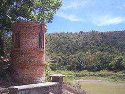
One of the finest mixed evergreen deciduous forest walks may be had at Wallings. Proceed westerly from John Hughes village up a slight gradient. At the top on turning to the left, is the pumping station of Wallings reservoir. From the station, start walking westerly to find the footpath that leads to the reservoir.
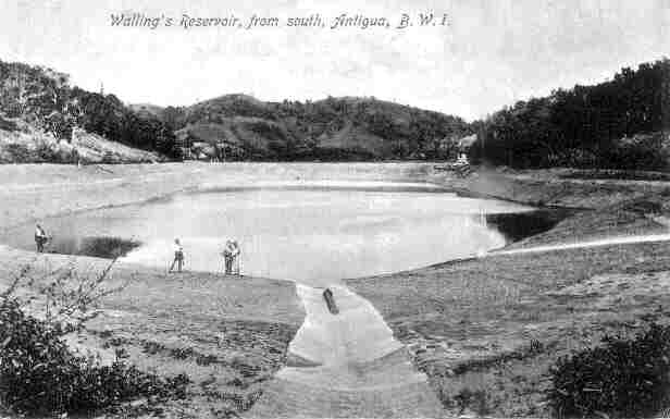
After walking about half a mile along dry scrubland with scattered trees, the spillway of the dam appears. The workmanship of this fine example of Victorian industrial architecture is truly magnificent with its rounded capping and small round tower. The reservoir was started in 1890, but there were complaints in 1897 that it could not hold water. However, it was finally finished to perfection in 1900. It was designed to hold 13 million gallons. Nine years later it had to be repaired again. It was then supplying thirty water tanks in fifteen villages. In 1912, after three years of drought, Wallings became empty, but later heavy rains fell in October and November of that year. A small additional dam creating the Fig Tree reservoir next to the main road was finished in November 1945. This was used to pump additional water up to Wallings. Together these two reservoirs cover 268 acres with a storage volume of 50 acres/ft.
 |
 |
|||
| THE SPILLWAY (OVERFLOW) |
THE VALVE HOUSE |
 |
 |
|||
|
WALLINGS IN 1900 |
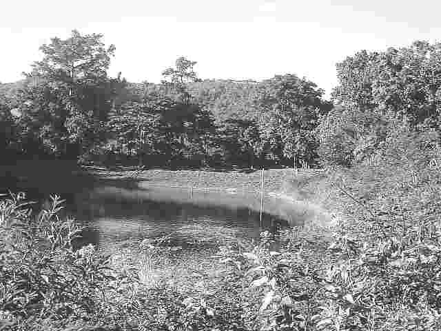
In 2000 |
In 1915, 13 acres of the reservoir catchment area were sown with tree seeds with a view to reforestation, as the area had become denuded after the turn of the century. In recent years some attention has been focused for both watershed protection and forestry products. Follow the east bank and find a rough footpath that meanders upwards into the forest. Proceed slowly and quietly to listen and watch for birds. If you are lucky you could observe a black whiskered vireo (Vireo altiloquus), Antillean euphonia (Euphonia musica) or a red-necked pigeon (Columba squamosa). On your way back, explore the back of the reservoir where some interesting water diversion channels and sediment traps can be seen.
The predominant tree species are locust (Hymenaea courbaril), ironwood (Exostema caribaeum), mahoe (Daphnosis caribaea), black loblolly (Pisonia fragrans), and mango, (Mangifera indica). Of the mid-level types are white cedar (Tabebuia pallida), turpentine (Bursera simaruba), and gunstock (Gauzuma martinicense). In the lower level are mahogany (Swietenia mohogani), Spanish oak (Inga laurina) and white prickle (Zanthoxylum martinicense).
In a certain area near the reservoir, picnic tables have been installed. Plan to make an outing into this section of Antigua's forest - a perfect place for peace and quiet in this bustling world - full of history and natural history.
THE 'PILLARS OF
HERCULES'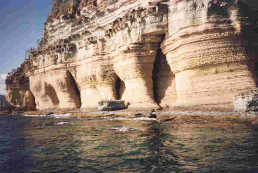
After a walk along the western peninsula that protects English Harbour to Fort Berkeley, another of Antigua’s natural attractions may be observed. The Fort is the best place to view the 'Pillars', other than by boat. Across the narrow harbour entrance is the ‘Pillars of Hercules’, caused by weather erosion of a softer rock. The large pillar-like formation faces the hot western evening. It is sheltered from the constant easterly trade wind with its accompanying showers. Thus, the soft sandstone rock becomes dry and crumbly. Wind eddies over eons of time have eroded the cliff into the spectacular formation seen today. Hawksbill Rock on the east coast, and the westerly sides of old ruins, are other examples of this geological action.
NELSON'S DOCKYARD NATIONAL PARK NATURE TRAILS

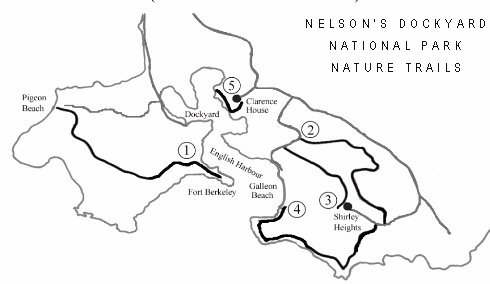
The Trails of the Nelson’s Dockyard National Park are:1. Middle Ground Trail 2. Jones Valley Trail 3. Lookout Trail 4. Carpenter Rock Trail 5. Clarence House Trail |
MIDDLE GROUND TRAIL (Fort Berkeley to Pigeon Beach)
Distance: 1 mile Elevation gain: 500feet Difficulty: moderate, with some scrambling over boulders
The Trail: Beginning at the trailhead at the entrance to Fort Berkeley, proceed up the short hill that will take you through some most interesting volcanic rock formations, bringing you to an open plain where Amerindian artifacts have been discovered and from where you can see spectacular views of Snapper Hole. Continue following the white dots on the rocks across the plain and on up the steep hillside to One Gun Battery. This is the only difficult part of the hike, but it is made quite simple if you follow the dots and use the steps carved into some of the rocks. From One Gun Battery and its lone Black Willow (Capparis sp.) tree, you have a commanding view of all of English Harbour. The trail continues over some large boulders -- be sure to see the ones on the left that have been hollowed out by soldiers of African origin who once ground their cassava in these “mortars”. Soon you are at Middle Ground. Here you will see the foundations of the barracks and the three interconnecting cisterns. (Do not walk on the bridge that connects two of them -- it is very unstable!!) Picking up the trail again, you’ll pass the ruins of the kitchen as you head to Fort Cuyler, about a third of a mile down the trail. Before reaching the Fort, there are a couple of overlooks from which you can see Snapper Point and Windward Bay; be sure to turn around and view the interior of Antigua as well! Fort Cuyler offers views of the entrance to Falmouth Harbour, Fort Charles (the small island on the other side of the Harbour), and the moorings at the Yacht Club. On a clear day, Montserrat is quite visible and to its right, the small island of Redonda, and in the distance, St Kitts. From the Fort, the trail picks up down the right side between the gun platforms and the foundations of the armory, following again the white dots. Parts of the descent can be steep; walk carefully! Steps have been built along one particularly difficult part. At the bottom of the steps, you’ll find Pigeon Beach, the end of the trail. Have a cooling swim!
To return, you may either retrace your steps or, for a much easier trek, proceed up the road to the right, staying to the right when you reach a junction half way up the hill. The road turns into macadam and as you approach English Harbour, you’ll see on your left the huge cistern built in about 1730 to supply the ships with water; be sure to read the sailors’ “graffiti” on the cement walls! From there, it is just a quick walk to the entrance to English Harbour.
Distance: 1 mile Elevation Gain: 500 feet Difficulty: easy, with some boulders to scramble over. Mostly in the shade.
To return, you may either retrace your steps or take the Lookout Trail that brings you out about 100 yards from where you started. For the more adventuresome, walk directly across the road, over the small rise, and take the Carpenter Rock Trail down to Galleon Beach.
LOOKOUT TRAIL (Lookout at Shirley Heights to Galleon Beach Road)
Distance: ½ mile Elevation Gain: 500 feet Difficulty: easy, with a few rocks to scramble over. Mostly in the shade.
To return, you could retrace your steps or turn to the right where, after 100 yards, you’ll see the trailhead sign for the Jones Valley Trail, that will also take you back to the top of Shirley Heights.
CARPENTER ROCK TRAIL (Fort Charlotte to Shirley Heights)
Distance: 1 ½ miles Elevation Gain: 500 feet Difficulty: the first half is moderate (there’s an alternate route to return); the second half, considerably more difficult, the most arduous of the trails. (A pocketknife or pliers for removing Turk’s Head cactus plant thorns from your shoes would be a very useful item to carry with you.)
The Trail: The trailhead is at Blue Haven the far end (southeastern-most) beach of Freeman’s Bay. You can reach it by either taking a dingy or by walking along and past Galleon Beach. Once at the trailhead, continue along the shoreline, walking over the rocks, almost to the point of land just opposite Fort Berkeley. You’ll see some ruins of gun platforms and buildings. It was here that the immense chain, that was stretched across the entrance to the harbour, was raised. Look across the water and you’ll see the imbedded cannon in the rock below the fort that secured the other end of the “floating” chain. The trail climbs quickly up to Fort Charlotte, from where a breath-taking vista of English Harbour and the Caribbean Sea can be seen. Even more spectacular views of rock formations and waves crashing on them are seen as you move along to Carpenter Rock. At one point, the trail diverges, with the white dots being the recommended trail and the red ones marking the trail for those where height is not a concern -- it does go near a cliff edge. At Carpenter Rock, there’s a huge cave near the water that is well worth a visit but to get to it you will need to do some careful scrambling over boulders. After exploring the cave, return to the trail, and either follow the dirt road on your left back to Fort Charlotte, or continue along the trail that is going to take you to the top of the most distant hill by way of Nanton Point, the hill you see off to the right along the shoreline! It will be steep at times, but the real annoyance will be the thorns from dead Turk’s Head cactus (Melocactus intortus); a device for removing them from your shoes would be most useful to carry! The trail leads along the flat rocks and meets goat paths that take you to Nanton Point. Super views of Antigua’s rugged southern coastline await those who get this far. It is all uphill from here, as the trail switches back and forth, past more caves and rock formations, and along promontories that make you glad you brought your camera. At the top is the site of the old hospital whose foundations can barely be seen. This is the end of the trail.
To return, you could retrace your steps (no way!) or proceed to the Lookout (the Sunday steelband location) and take the Lookout Trail back to Galleon Beach. For those of you still looking for more exercise, take the Jones Valley Trail back! (If you walk to the small rise on your right as you leave the signpost, you’ll see the one for Jones Valley, just across the road.)
CLARENCE HOUSE TRAIL (Old Wharf to Clarence House)
Distance: ¼ mile Elevation Gain: 200 feet Difficulty: easy, very
The Trail: The hardest part about this walk is finding the old stone wharf that marks the trailhead! To find it, leave by boat (there's a ferry available) from the capstans in English Harbour and go directly across the harbour, steering towards the mangroves to the left of Clarence House. As you approach the shoreline, you should see the wharf jutting out from the mangroves. Secure the dingy and follow the trail to the immediate right along the shoreline. Soon you will arrive at the immense anchor with one of its flukes firmly buried in the ground; it was used to aid in warping the Men of War into the Dock. Further along the trail, you’ll encounter rows of wide concrete slabs set in the hillside -- they are the remnants of the viewing area for the “Son et Lumiėre" (“Sound and Light”), a 1960’s production that told the story of English Harbour. Another 50 yards up the trail and you are at Clarence House, the home built for the Commissioner of the Dockyard in1806 and presently under restoration. Many of the photos for posters and postcards of English Harbour have been taken from this vantage point.
To return to your dingy, either retrace your steps, or take the much shorter and easier route down the dirt track to the right as you face the Harbour.
| WARNINGS! | A DISCLAIMER! | |||
|
|
The good news is that there are no snakes, the lizards are harmless, mongooses flee at the sight of you, any strange noise in the bush is the sound of goats leaving quickly. So what do you have to be concerned about? 1. The Manchineel tree, with the little green apples (sometimes black). Poisonous. DO NOT touch any part or sit under a tree when it rains. Just Keep away! It causes burns. 2. Thorns. Make sure you do not reach for a handful of thorns instead of support. |
|
With any outdoor activity, especially one involving climbing over boulders as these trails do, there is a chance of injury. Your use of the trails is your consent that the National Parks will not be held responsible for any injuries sustained. While we have made these trails as 'friendly' as possible, mishaps can occur. We encourage you to be careful. Please have a fun, safe, and relaxing time on the trails! |
|
PLACES TO GO BIRD WATCHING

The birds of Antigua and Barbuda “help to open visitors’ eyes to their beautiful surroundings”.
Danforth in a 1934 list shows 87 species of birds for Antigua, 6 of which were considered hypothetical. He saw 61 species in a three-week stay. In 1977, in 20 hours of observation, Holland & Williams saw 61 of 91 species regularly seen on Antigua. In 1985, it was said there were 109 species and in 2004 about 120.
Places to go birding:
McKinnon’s Pond, North Sound Islands, Fitches Creek, Sugar Factory Ponds, Christian Valley, Dark Wood, Boggy Peak, Wallings Forest, Collins Reservoir, Potswork, Bethesda Reservoir, Windward Bay, Ayres Creek, Barbuda Lagoon.
McKINNON’S POND - Osprey, Frigate Bird, Brown Pelican, Greater Yellow Legs, Spotted Sandpiper, Cattle Egret, Great Egret, White Cheeked Pintail, Wilson’s Plover, Ruddy Turnstone, Great Blue Heron, Little Blue Heron, Common Gallinule, Black Necked Stilt, Zenaida Dove, Carib Grackle, Kingbird, Black Faced Grassquit.
POTSWORK - Pied-Billed Grebe, Osprey, Great Blue Heron, Black Crowned Night Heron, Great Egret, Cattle Egret, Snowy Egret, West Indian Whistling Duck, White Cheeked Pintail, Blue Winged Teal (winter), Common Gallinule, Killdeer, Greater Yellow Legs, Black Faced Grass quit, Grey Kingbird, Yellow Warbler
BOGGY PEAK - Scaly-naped or Red Necked Pigeon
WALLINGS FOREST - Antillean Euphonia, Red Necked Pigeon. Wallings Dam – Broadwinged Hawk, Grey Kingbird, White Crowned Pigeon, Bananaquit, Antillean Crested Hummingbird, Belted Kingfisher, Redstart, Black-whiskered Vireo, Antillean Bullfinch, Black-faced Grassquit,
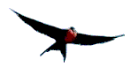
NORTH SOUND ISLANDS - Broadwinged Hawk, Sparrow Hawk, Osprey, Frigate Bird, West Indian Tree Duck, Fulvous Whistling Duck, White-cheeked Pintail, Sooty Tern, Roseate Tern, Least Tern, Bridled Tern, Brown Noddy, Laughing Gull, Red-billed Tropic Bird, Brown Pelican, White Crowned Pigeon, Zenaida Dove, Mangrove Cuckoo, Grey Kingbird, Caribbean Elaenia, Black–whiskered Vireo.
BODY PONDS - Road – Zenaida Dove, Grey Kingbird, Black-faced Grassquit, Ground Dove
BARBUDA LAGOON - Magnificent Frigate Birds, Brown Pelican, Brown Booby, Royal Tern.
Your bird watching contacts in Antigua & Barbuda are:
Junior Prosper. Tel: 268 773-1159
Victor Joseph. Tel: 268 775-1495 or 460-1651
The serious as well as the casual birder will be provided with informative assistance in finding and identifying the birds that reside or visit our shores.
Bird Guide Victor Joseph is available on Sundays 6 am to 9 am and Mondays to Thursdays 3 pm to 6 pm.
Fee US$30/person. One day's notice will be greatly appreciated. vjosephlib@yahoo.com
THE BOTANICAL GARDEN
The Botanical Garden, if rehabilitated, could provide a fine park-like setting to increase public awareness and an appreciation of plants and the natural environment. It would be used as a place for relaxation and meditation for it is a natural oasis in town with an aesthetic setting for social interaction.
Botanic gardens provide an atmosphere for group discussions and other services that encourage the exchange of environmental and botanical information among interested groups and individuals. Gardens are tourist attractions, as visitors are always keen to learn about the plants of the land they are witnessing. Botanic gardens can be laboratories in which schoolchildren appreciate natural sciences. Antigua could use a Botanical Garden for agricultural purposes, providing a wide range of species.
The Botanical Garden is located in Victoria Park at the top of St. John’s in the “greenbelt” area of the city. It borders the Queen Elizabeth Highway and Independence Avenue. The Garden is just to the east of the National Archives and the site for the new Public Library building.
The Garden was created in 1893, and its eight acre site became the only real park in St. John’s. In 1918, a visitor from the University of Iowa wrote that the Garden was laid out “with much art and was well kept”. However, in following years the Garden gradually lost its popularity and by the 1960’s it had greatly deteriorated.
In 1987, the Botanical Garden Society was formed and two years later a legal Board of Governmental and non-governmental members was established. Much work was done, and in 1993 centennial celebrations were held.
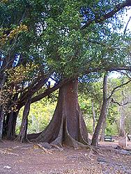
As you enter the historic Garden you are immediately captivated by the unfolding majesty of an 80 year old African Cloth Bark Tree or Zulu Tree (Ficus nekbuda). The height of the tree is about forty feet high and spreads out about fifty feet and the trunk is enormous. This species is a native of tropical East Africa, where the bark is used to make cloth. The magnificent splendor of this massive tree is contrasted by rolling lawns, providing open space for family get-togethers.
An earlier inventory of plants in the Botanical Garden shows that other trees were present:
Cuban Royal Palm (Roystonia regia) – This is a very stately palm with clean lines, often used for formal ornamental purposes. The trunks often grow to sixty feet high. The genus is named after General Roy Stone an American engineer once stationed in Puerto Rico. The oily seeds have been used for fattening pigs and chickens.
Lignum Vitae (Guiacum officinale), known locally as “Nigger vitey”, was once common on Antigua, but it was in great demand for the wooden parts of Antigua’s 109 sugar mills, as well as for medical purposes.
Yellow poui (Tabebuia glomerata) is truly beautiful when blooming in February, when it is covered with golden flowers. Afterwards it becomes nearly leafless. It is a fine ornamental and shade tree and a native of the southern West Indies.
Devil’s Ear (Enterolobium cyclocarpum). This is named after the brown earlike seeds that dangle from the tree after it has lost its feathery foliage. Used for shade and ornament in playgrounds and parks. It gives a good substitute for gum arabic, makes tannin, soap and medicine. The toasted seeds are edible.
Sausage Tree (Kigelia africana) Its very large seeds weigh up to 14 lbs each and dangle from its branches for many months. The wine coloured flowers have an unpleasant odour. They drop each morning after blooming at night. The large seeds were used as an external medical. They are inedible.
Hazel Sterculea (Sterculea foetida). There are two in the Gardens. They flower in April with a foul stench. The tree has been introduced from Asia. There is another specimen at Side Hill.
Mast Wood (Sideroxylon foetidissimum). This tree has yellow flowers and is a fair honey plant. It was once used as a heavy hard wood for construction, boats, heavy planking, furniture and fence posts.
White Wood (Bucida buceras). Its wood is very heavy, hard and strong. It was once known in Antigua as Black Gregory and was used for making gun carriages at the forts.
Bamboo (Bambusa vulgaris). An attraction in the Garden is a large stand of bamboo. This member of the grass family is widely used as a handcraft material. Leaves are sold in the Market as a tea for colds and coughs. Bamboo was introduced into the West Indies from Asia many years ago.
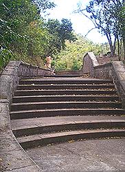
In the Garden is a small canyon, and on the steps to this shady gully you’ll be greeted by the melodious sounds of birds and tree frogs, which emanate from the hollow, beckoning you from its depths. Here hanging lianas drape from the branches of trees . Looking downward you’ll find the source of an audible rustling in the fallen leaves a ground lizard, one of three species found in Antigua. While gazing from the gazebo overlooking the canyon, you might watch a couple arm-in-arm as they enjoy nature in the quietest spot of bustling St. John’s. In the Garden there was once a playground and a bandstand.
In 1987, the following projects were planned: an aviary, an aquarium, a reptile house, a visitor’s centre and a fountain, but unfortunately due to a lack of funding these projects never materialized. Collections of orchids, ornamental shrubs, frangipanis, epiphytes, ferns and palms were also being made. With the new dispensation of Government, which has lead to a new awareness of the general public, there are a few persons taking a new interest to rehabilitate the Botanical Garden. In June 2004, Government appointed a Board to restore the Garden to its original beauty and to raise funds for that purpose.
Take a few moments out of your busy schedule and reflect on the beauty of nature that may still be seen around you in this historic spot. Perhaps there may be found the glory of nature to soothe the spirit and give you a peace of mind!